 It is impossible to separate health and place. This simple truth forms the basis of all understanding in modern environmental health. Local health departments working in the environmental health field should ensure they are well-versed in the tools that highlight the hazards, threats, and peculiarities particular to their communities; in particular, they should be familiar with Geographic Information Systems (GIS). GIS gives public health professionals the ability to analyze immense amounts of demographic, statistical, and geospatial data to develop visual representations that are easily digestible at all levels.
The use of GIS by local health departments benefits programs and initiatives in a number of ways, including:
Cost saving:
Using geospatial technologies, local health departments can streamline resources to provide solutions where they are needed. This approach minimizes planning costs and frees funding to maintain or grow the high-quality services health departments provide to their communities. This is especially important in a time where the demand to do more with less is high.
Better story telling:
It’s said that a picture is worth a thousand words; in that case, data-driven GIS maps are likely worth around 10 million words. Perhaps one the strongest benefits of working with GIS is the visualization of complex, large data sets in a way that translates easily to all levels. Health departments serve as centers of information for the community, advocates for endemic issues, and representatives for their jurisdiction to larger health entities. This distinction means local health departments must be able to explain their work to subject matter experts and the public alike. GIS helps to bridge that gap. Maps, particularly at the local level, offer profound insight into issues that are often blurred when viewed through a state or national lens.
Better decision making:
By providing visualizations of complex datasets, GIS makes it easier for local health departments to make critical decisions. Trends that might not be identified without time-consuming analysis become quickly apparent when mapped, allowing for a more informed process. Through GIS, it is possible to track issues of time and space, and to synthesize data exponentially faster than by traditional means. In some ways it is possible to model projections from past data, effectively building a visible record for use in present day decision making.
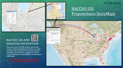
An obvious application of GIS-based decision making is in disaster response. In any response effort the emergency operations center always has a map, in some form or another, on the wall. This is a tool used by command staff and response coordinators to direct equipment, services, and workers to areas in need. Using GIS, these officers can look beyond a static, 2-dimensional map to find and visualize local data that may not be immediately apparent during a response (such as vulnerable populations). Additionally, when the situation map lives within GIS software, users can manipulate the data to project different criteria necessary to certain periods along the response timeline. Furthermore, GIS modeling can aid in recovery and restoration efforts, allowing local health departments or responding organizations to effectively treat a battered community.
NACCHO has begun to expand its GIS capabilities internally to serve a growing need in its membership. Recognizing the value to its membership, NACCHO has pursued a partnership with Esri, the foremost brand in GIS software. As a result of this partnership, NACCHO has GIS experts on staff able to create data-rich, visual analyses in innumerable applications.
NACCHO is always looking for partnerships with local health departments to share GIS tools, methods, and data to improve local health outcomes. If your health department is interested in improving its GIS analysis capabilities or creating specific mapping products, NACCHO may be able to help in a collaborative service. If you or your organization is interested in exploring GIS solutions with NACCHO, please contact the GIS program.